Welcome to TrueSize.net
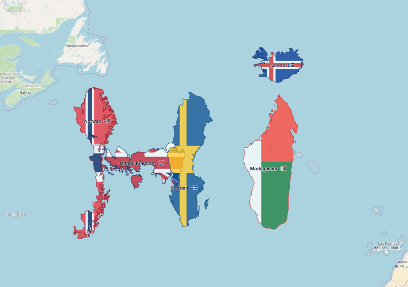
TrueSize.net is a free, interactive tool that reveals the true size of countries, states, and historical territories on accurate projections. Unlike traditional Mercator maps that distort sizes (making Greenland appear as large as Africa), TrueSize lets you drag countries around the globe to see their actual comparative sizes. Whether you're comparing modern nations, US states, or ancient empires like Rome and the Soviet Union, TrueSize provides an accurate, visual understanding of geographic scale.
Why TrueSize?
Most world maps use the Mercator projection, which dramatically exaggerates the size of countries near the poles while shrinking equatorial regions. TrueSize solves this by:
- Spherical calculations — All transformations happen on a 3D sphere for mathematical accuracy
- True size comparisons — Move countries, states, provinces, and even entire continents anywhere on the map or globe to see how their size changes with latitude
- Unmatched granularity — With 88,000+ regional subdivisions (more than any other map comparison tool), compare Texas to France, California to Italy, or Alaska to Libya with pinpoint accuracy
- Historical accuracy — Compare modern borders with historical empires across 60+ time periods from 123,000 BC to today
- Interactive learning — Drag, rotate, and position countries, regions, and continents to understand real-world geography
Key Features
🌍 Dual Visualization Modes
- 2D Interactive Map — Leaflet-based flat map with holonomy-aware transforms (countries rotate realistically as you move them)
- 3D Globe View — Cesium-powered globe for true spherical perspective and orbital camera controls
📏 Accurate Size Comparisons
- 270+ modern countries and territories with precise GeoJSON boundaries
- 88,000+ subdivisions and regions — US states, Canadian provinces, German Länder, Russian oblasts, and more for hyper-detailed comparisons
- 6 continents — Compare entire continental landmasses (Africa, Antarctica, Asia, Europe, North America, South America)
- Spherical geometry engine — All size calculations use Earth's curvature, not flat projections
⏳ Time Travel Through History
- 60+ historical time periods from 123,000 BC to 2010 AD
- Compare Roman Empire, Soviet Union, Ottoman Empire, and other historical boundaries
- Overlay modern countries on historical maps to see territorial changes
- Era-specific data with accurate population and area statistics for each time period
🎨 Styling
- Flag-based coloring — Countries display their actual flag colors and patterns
🧩 Custom Data (GeoJSON / TopoJSON)
- Custom import — Load your own boundary data for niche or higher‑resolution analysis
- Export — Save transformed geometry as GeoJSON for reuse
📊 Country & Region Tooltips
Hover to view:
- Official name
- Current / historical population (era-dependent)
- Land area (km² & mi²)
- Selected historical & geographic context
Who is TrueSize For?
🎓 Educators & Students
- Geography lessons — Teach true country sizes and projection distortion
- History classes — Visualize historical empires and territorial changes
- Presentations — Create compelling visuals for lectures and assignments
- Homework help — Interactive tool for understanding scale and geography
💼 Professionals & Researchers
- Data visualization — Create accurate geographic comparisons for reports
- Publishing — Export maps for articles, books, and presentations
- Urban planning — Compare city sizes and regional boundaries
- Academic research — Analyze historical territorial changes over time
🌐 Travelers & Geography Enthusiasts
- Trip planning — Understand the real scale of destinations
- Distance perspective — See how far apart places truly are
- Cultural exploration — Compare regions and understand geographic diversity
- Personal projects — Create custom maps for blogs, videos, or social media
📰 Content Creators & Journalists
- Infographics — Generate size comparison visuals for articles
- Social media — Create shareable geographic content
- Educational videos — Screen record the interactive map for tutorials
- Story illustrations — Visualize geographic context for news stories
📱 TrueSize Mobile Apps
Take TrueSize with you anywhere! Our free mobile apps bring the full power of interactive geography to your phone or tablet.
Download Now
- TrueSize for Android — Available on Google Play

- TrueSize for iOS — Available on the App Store

Mobile Features
- ✨ Full feature parity — All map features, historical periods, and data available on mobile
- 📍 Touch-optimized — Intuitive gestures for dragging, rotating, and selecting countries
- 🎯 Native performance — Fast, smooth map interactions with native mobile optimizations
- 📤 Share & export — Save and share your comparisons directly from your device
Whether you're teaching in a classroom, exploring on a trip, or just curious about geography, TrueSize mobile puts accurate world comparisons in your pocket.
Is It Free?
Yes! TrueSize.net is completely free to use:
- ✅ No account registration required
- ✅ Unlimited countries and comparisons
- ✅ All historical time periods included
- ✅ Full export capabilities
- ✅ Commercial use permitted
- ✅ Free mobile apps for iOS & Android
To support us, please consider turning off ad blockers and occasionally clicking on our ads. It really means a lot to us. Thank you!
Attribution & License
Maps and visualizations you create with TrueSize are free for private and commercial use. Attribution is appreciated (but not required):
- Recommended: "Created with TrueSize.net"
- Alternative: Keep the built-in "TrueSize.net" watermark visible
- Minimal: Include a link to TrueSize.net in your credits
Data Sources & Thanks
Base Map Data
- Modern boundaries: OpenStreetMap contributors
- Historical maps: Historical Basemaps project by Alexandre Ourednik
- Satellite imagery: Esri World Imagery
- Geographic data: Natural Earth Data
Special thanks to the open‑source community and geographic data maintainers who make projects like this possible.
Who Built This?
TrueSize is built and maintained by a single, map-obsessed developer passionate about making geography accessible and accurate. The project started from a simple question: "Why does Greenland look bigger than Africa on most maps?" and evolved into a comprehensive tool for geographic education and visualization.
Get in Touch
- Reddit: r/TrueSize — Community discussions and feature requests
- Bug reports: Use Reddit for now; GitHub coming soon
- Custom development: Contact via Reddit for new features or questions
Our Friends & Partners
GuessWhereYouAre.com — Free Geography Guessing Game
Love maps? Test your spatial skills with GuessWhereYouAre!
Drop into random Google Street View scenes worldwide and race to identify the country (or exact location) before time runs out. Inspired by GeoGuessr, but built for fast, free play in your browser.
Features:
- Daily challenges with global leaderboards
- Multiplayer mode for competing with friends
- Educational focus — Learn flag recognition, architecture, vegetation, and cultural clues
- Free to play — No sign-in required

Perfect for TrueSize users who want to test their geographic knowledge interactively! Available also under shorter domain FreeGuessr.com!
TuneJourney™ — Live Radio Globe powered by AI
TuneJourney brings together more than 70,000 live radio stations across 11,000+ cities and regions, with browser-based AI that listens in real time to detect music, talk, ads, and noise. Features:
- Interactive 3D globe for discovering stations by city, region, country, genre, bitrate, and language
- AI audio intelligence that can auto-skip DJ chatter and ad breaks to keep music playing
- ISS Auto-Tune that follows the International Space Station and switches to nearby radio stations as it orbits Earth
- Favorites and playlists with cross-device sync for signed-in listeners
- Always free — no signup required to start listening
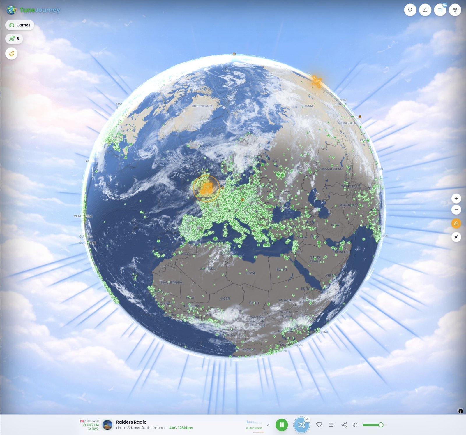
Perfect for TrueSize users who enjoy exploring the world through real places, local culture, and live sound.
🗺️ PaintMyMap.com — Custom Map Creator
Need publication-ready, styled maps? Visit PaintMyMap.com!
PaintMyMap offers professional map creation with:
- Choropleth maps with data-driven coloring
- Labels, legends, and annotations for polished presentations
- Print-quality exports (PDF, SVG, high-res PNG)
- Statistical overlays and custom data visualization
- Hundreds of base maps — country, regional, and thematic options
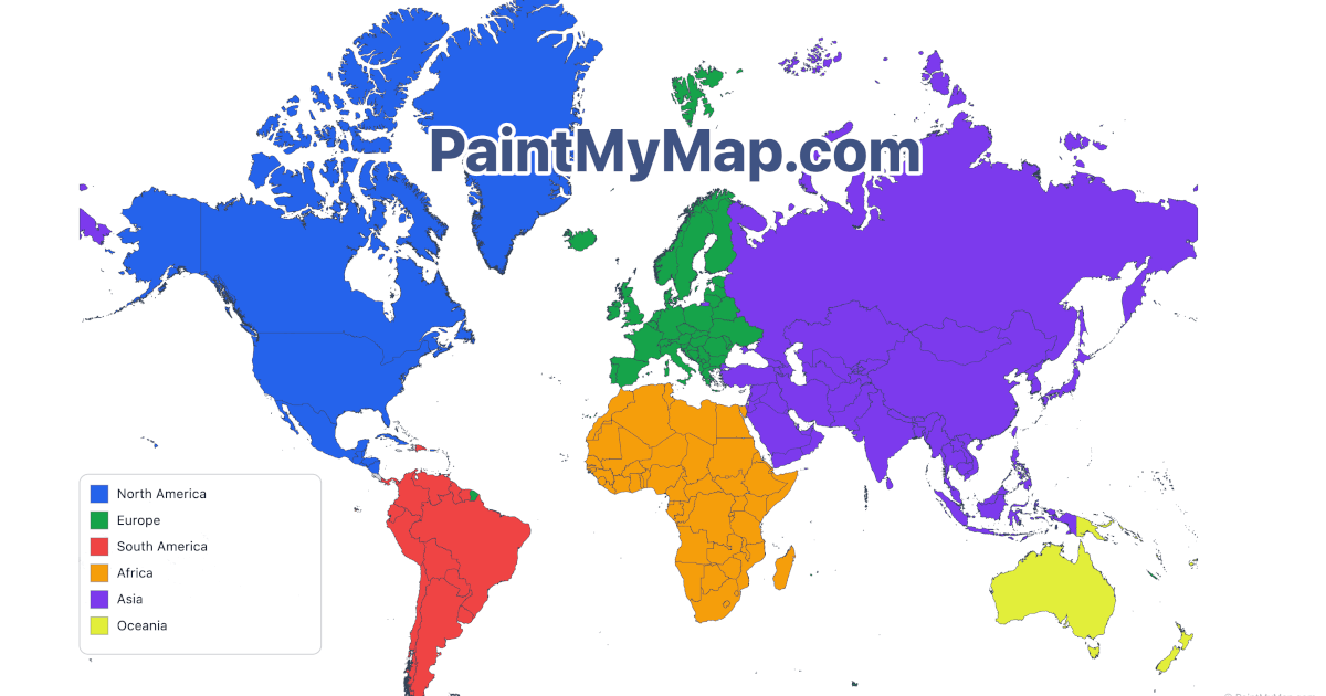
TrueSize is great for size comparisons; PaintMyMap excels at detailed, styled cartography. Use them together for comprehensive map projects!
🗺️ GeoUtil.com — Free Online Map & Geography Tools
Need free online map and geography tools? Visit GeoUtil!
GeoUtil offers an all-in-one online geography toolkit with:
- Measure distance & area — Calculate precise measurements on interactive maps
- Convert formats — Transform GeoJSON, TopoJSON, and JSON files effortlessly
- Merge or minify files — Optimize your geographic data for better performance
- Fast, free, and browser-based — No downloads or installations required

Perfect for TrueSize users who need additional map utilities and geography tools!
Wikimedia Commons
Some flag icons are sourced from Wikimedia Commons and are used under their respective licenses.
Feedback & Roadmap
TrueSize is actively developed based on community feedback. Your input shapes the future! Join the r/TrueSize community to share ideas, report bugs, and vote on features.
TrueSize™ is an independent interactive map tool and is not affiliated with any other “True Size” website.