Inspiring TrueSize Examples & Geographic Comparisons
Discover what's possible with TrueSize.net — the interactive tool that reveals the true size of countries by correcting map distortions. From comparing continents to exploring the world's largest regions and smallest nations, these examples will change how you see our planet.
Interactive Examples
Click any link below to explore these comparisons yourself on TrueSize.net. Drag countries anywhere on the map to see how latitude affects their apparent size!
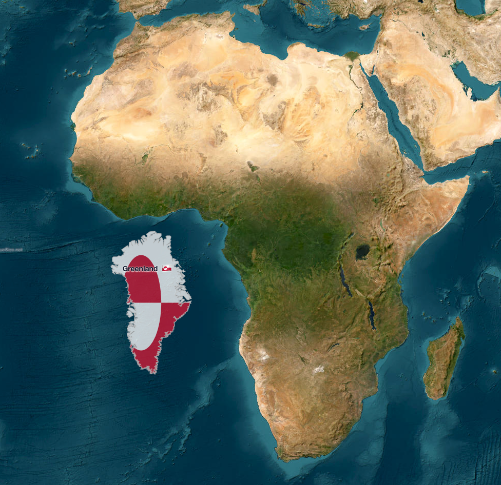
The True Size of Greenland vs Africa
Popular myth: Greenland looks as big as Africa on most world maps. Reality: Africa is actually 14 times larger than Greenland!
On standard Mercator projections, Greenland (2.17 million km²) appears roughly the same size as Africa (30.37 million km²). This dramatic distortion happens because Mercator maps exaggerate landmasses near the poles. When you place Greenland next to Africa on TrueSize, the difference becomes strikingly clear.
→ Try this comparison yourself
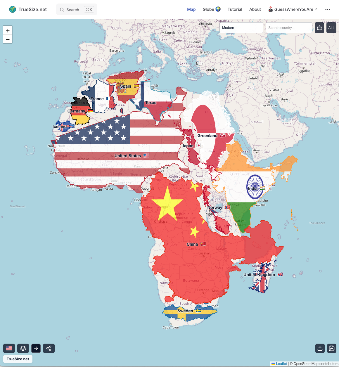
How Big is Africa Really? The Size Comparison That Changes Everything
Africa is massive — but world maps hide its true scale. This comparison reveals just how many major countries and regions can fit inside the African continent:
- 🇺🇸 United States (9.8 million km²)
- 🇨🇳 China (9.6 million km²)
- 🇮🇳 India (3.3 million km²)
- 🇪🇺 Western Europe combined
- 🇯🇵 Japan and more!
Combined, these still don't fill Africa's 30.37 million km²
Most people underestimate Africa's size by 2-3 times due to Mercator projection distortion. This visualization demonstrates why Africa is truly the world's second-largest continent and home to over 1.4 billion people across 54 countries.
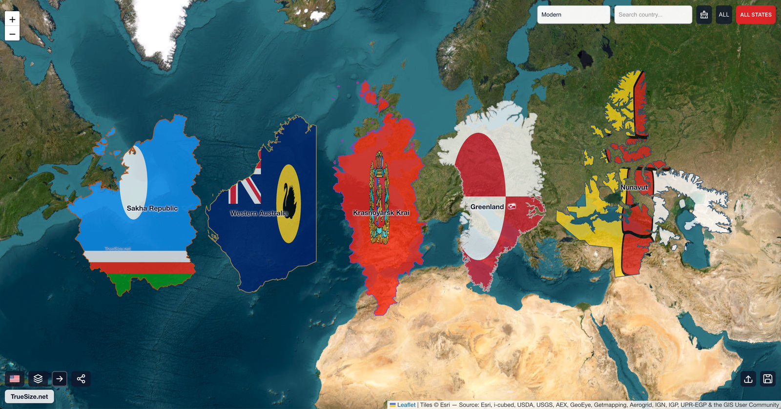
🌍 The 5 Largest Subnational Regions on Earth
These administrative divisions are larger than most countries — some even rival entire continents in size. Here are the world's biggest provinces, states, and territories:
1. 🇷🇺 Sakha Republic (Yakutia), Russia
- Area: 3,083,000 km² — larger than Argentina!
- Population: ~960,000 (one of the lowest population densities on Earth)
- Notable: The coldest inhabited place on Earth; contains the world's largest diamond mines
2. 🇦🇺 Western Australia
- Area: 2,646,000 km² — about the size of Western Europe
- Population: ~2.8 million
- Notable: Covers one-third of Australia's landmass but only 11% of its population
3. 🇷🇺 Krasnoyarsk Krai, Russia
- Area: 2,366,000 km² — larger than Saudi Arabia
- Population: ~2.8 million
- Notable: Stretches from Mongolia to the Arctic Ocean; home to vast Siberian wilderness
4. 🇬🇱 Greenland (Denmark)
- Area: 2,166,000 km² — the world's largest island
- Population: ~56,000 (mostly Inuit)
- Notable: 80% covered by ice sheet; autonomous territory of Denmark
5. 🇨🇦 Nunavut, Canada
- Area: 2,093,000 km² — one-fifth of Canada's total area
- Population: ~40,000 (primarily Inuit)
- Notable: Created in 1999; Canada's newest, largest, and least populous territory
→ Compare the world's largest regions
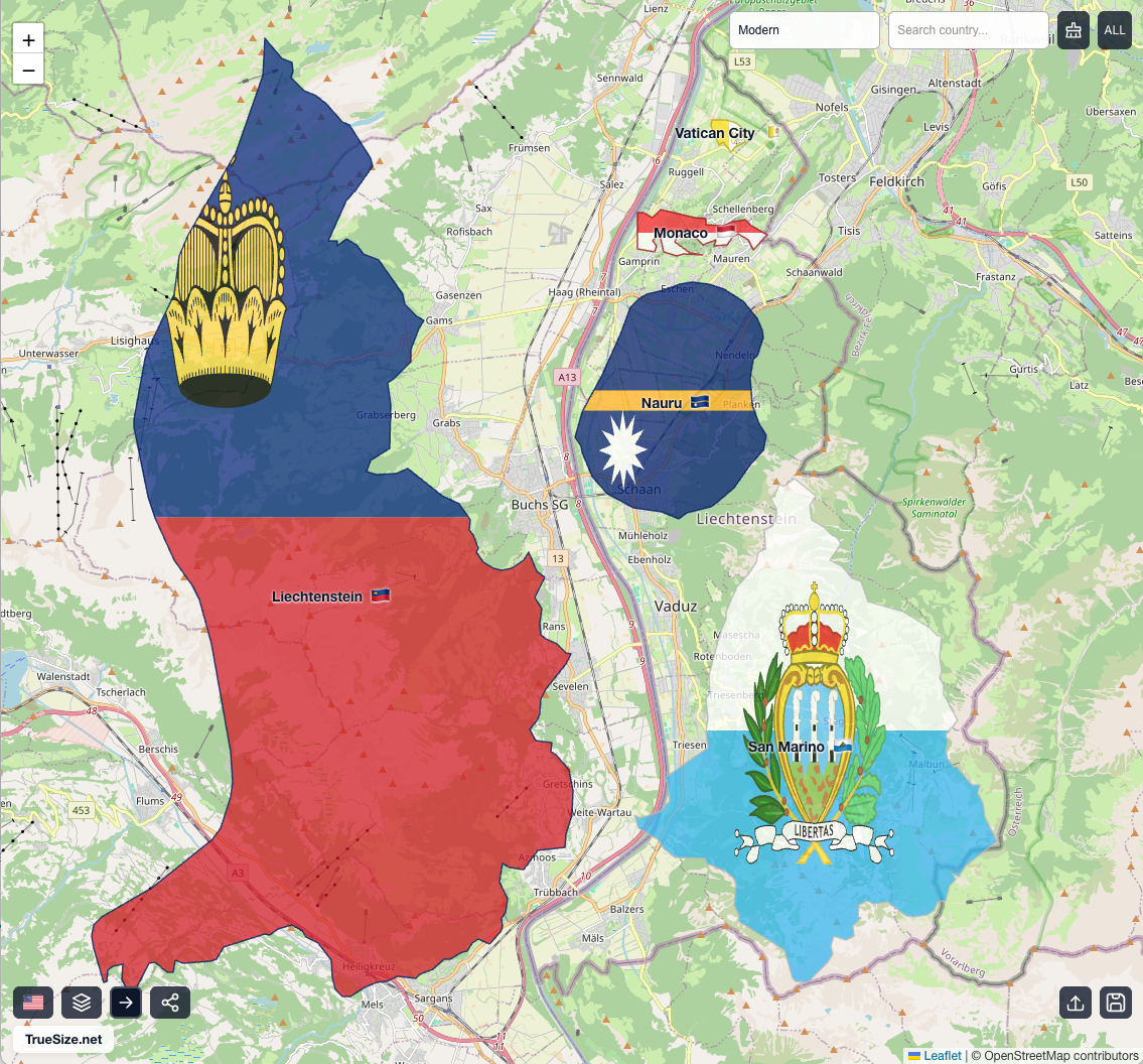
🏝️ The World's 6 Smallest Countries — All Fit Inside Liechtenstein
Here's a mind-bending fact: The top 4 smallest countries (excluding Tuvalu) can fit entirely within the 6th smallest country, Liechtenstein. These microstates pack remarkable culture, history, and sovereignty into astonishingly tiny spaces:
1. 🇻🇦 Vatican City
- Area: 0.44 km² — about 108 acres
- Population: ~800
- Notable: The world's smallest independent state; headquarters of the Catholic Church
2. 🇲🇨 Monaco
- Area: 2.02 km² — smaller than New York's Central Park
- Population: ~38,000
- Notable: World's most densely populated country; famous for Monte Carlo and F1 racing
3. 🇳🇷 Nauru
- Area: 21 km² — the world's smallest island nation
- Population: ~12,000
- Notable: Pacific island republic; once wealthy from phosphate mining
4. 🇹🇻 Tuvalu*
- Area: 26 km² — spread across 9 coral atolls
- Population: ~11,000
- Notable: One of the world's most climate-vulnerable nations due to rising seas
5. 🇸🇲 San Marino
- Area: 61 km² — entirely surrounded by Italy
- Population: ~34,000
- Notable: The world's oldest republic, founded in 301 AD
6. 🇱🇮 Liechtenstein
- Area: 160 km² — big enough to contain the first 4!
- Population: ~39,000
- Notable: Prosperous Alpine nation between Switzerland and Austria
*Note: Tuvalu was excluded from the comparison visualization since it consists of multiple scattered islands rather than contiguous territory.
→ Explore the world's tiniest nations
🕰️ Historical Maps: Explore the Past with Accurate Projections
TrueSize.net includes historical boundaries spanning from 123,000 BC to 2010 AD! See how empires, nations, and borders evolved throughout human history — with accurate geographic sizes.
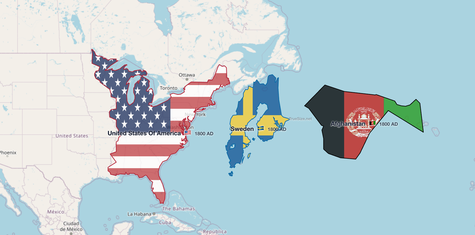
Example: The World in 1800
Compare the territorial extent of three major powers as they existed in the year 1800:
- 🇺🇸 United States — freshly independent, before westward expansion
- 🇸🇪 Sweden — including much of modern Finland
- 🇦🇫 Afghanistan — the Durrani Empire at its height
When placed at their true latitudes, you can see how map distortion affects our perception of historical empires. Sweden appears much larger on typical maps due to its northern latitude, while Afghanistan's true size becomes clear.
⏳ Compare Empires Across Different Eras
One of TrueSize's most powerful features: overlay countries and empires from different time periods to see how their territories compare at their true scales.
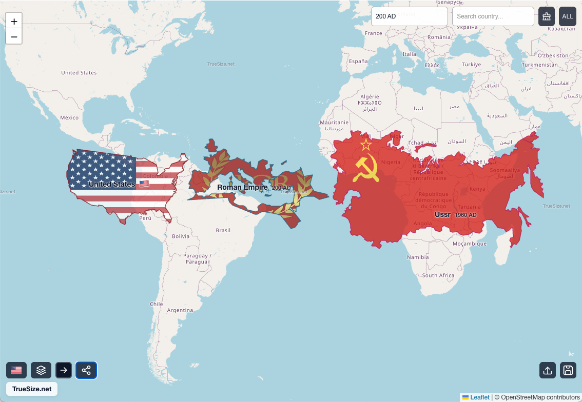
Example: Modern USA vs Historical Superpowers
This visualization compares three major powers from different centuries:
- 🇺🇸 United States (modern borders) — 9.8 million km²
- 🚩 Soviet Union (1960s) — 22.4 million km² at its peak
- 🏛️ Roman Empire (c. 200 AD) — 5 million km² at maximum extent
Seeing these side-by-side reveals:
- The USSR was truly massive — nearly 2.3× the size of the modern USA
- The Roman Empire, while influential, was geographically smaller than often imagined
- How latitude affects perception: the USSR's northern territories appear even larger on standard maps
Perfect for history teachers, students, or anyone curious about the true geographic scale of historical empires!
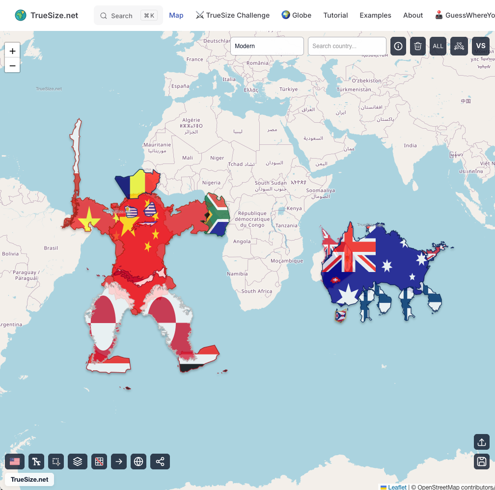
🎨 Have Fun with the World and Maps
When you're done exploring Mercator distortions, unleash your creativity and imagination!
Move, duplicate, rotate, and flip countries to create amazing creatures and artistic designs. You won't believe how fast and easy it is!
🎯 Ready to Explore?
These examples just scratch the surface of what you can discover with TrueSize.net. Whether you're a teacher, student, geography enthusiast, or just curious about the world, start comparing countries and empires today — and see our planet as it really is.