Sharing & Exporting
After arranging and rotating your countries, you can share the exact configuration, import your own geographic files, or export the transformed geometry in several common GIS formats.
URL Sharing (Compressed Deep Link)
Your current state (camera, selected items, positions, rotations, colors, options) is compressed into the URL hash. Just copy the browser URL—no account needed.
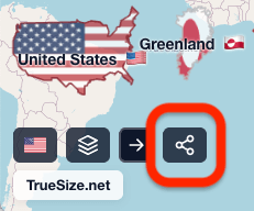
How to Share
- Select and position countries (rotate if desired)
- Copy the full URL (hash includes compressed state)
- Paste into email, chat, social media, or embed it
- Anyone opening it restores the identical map/globe configuration
Notes & Limits:
- When you import custom data from a GeoJSON or TopoJSON file, the Share button will be disabled.
- If you add too many countries and the maximum URL length is reached, the Share button will also be disabled. You can typically share maps with 30–50 countries, but if you hit the limit, try removing some regions.
Export Transformed Geometry
Export applies all transformations (translation + rotation) to geometry before packaging.
Available formats:
- GeoJSON for scripts, notebooks, GIS tools, and importing back into TrueSize
- TopoJSON for topology-aware, smaller web map workflows
- KML for Google Earth and compatible desktop viewers
- Shapefile ZIP for classic GIS pipelines
Use cases:
- Classroom or research visuals
- Import into GIS / data viz tools
- Archive a comparison snapshot offline
Import Custom Data
Add your own polygons for specialist analysis, then reposition relative to built‑in shapes. Supported imports include:
- GeoJSON
- TopoJSON
- KML
- GPX
- Zipped Shapefiles
Custom layers are included in export, subject to the same built-in export limits noted above.
Poster Artwork Exports
If you want printable map art rather than raw geographic geometry, use Poster Preview instead. Poster mode exports PNG, PDF, and SVG artwork.
See the dedicated Create a Map Poster guide for that workflow.
Next: Return to the tutorial index, learn how to create a map poster, or explore the About page.