
English
English
Appearance
In 1920 and 1921 the British Empire covered about 33.6 million km², measured from its outline in TrueSize. Published estimates put it at about 35.5 million km², almost a quarter of the world's land. That is more than the whole of Africa (about 30.3 million km²) and about four times the 48 contiguous US states. In 1913 about 412 million people, almost a quarter of humanity, lived under British rule.
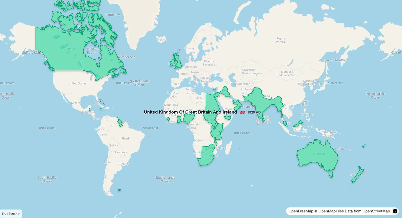
The British Empire in 1920, the year it reached its largest extent in the TrueSize timeline.
| Region | Area | Source |
|---|---|---|
| British Empire, 1920 | 33.6 million km² | measured in TrueSize |
| British Empire, 1920 | about 35.5 million km² | published estimate |
| Africa | about 30.3 million km² | common total |
| Mongol Empire, 1279 | 27.09 million km² | measured in TrueSize |
| Soviet Union | 22.02 million km² | measured in TrueSize |
| Russia today | about 17.1 million km² | official total |
| Contiguous 48 US states | about 8.1 million km² | official total |
Historians count colonies, protectorates and mandates differently, so published totals vary by a few million km². The TrueSize figure uses one outline for each year, the same method as for every other empire on the site.
The United Kingdom's entry in the TrueSize timeline carries the whole empire, so you can watch it grow and shrink.
| Year | Area in TrueSize | What changed on the map |
|---|---|---|
| 1858 | 15.7 million km² | the British Crown takes over the rule of India |
| 1899 | 29.1 million km² | Sudan comes under joint British and Egyptian rule |
| 1914 | 32.5 million km² | the First World War begins |
| 1920 | 33.6 million km² | the peak, with former German colonies under British rule |
| 1922 | 32.6 million km² | the Irish Free State and Egypt leave |
| 1931 | 24.2 million km² | Canada leaves the outline under the Statute of Westminster |
| 1934 | 22.6 million km² | South Africa leaves |
| 1939 | 15.4 million km² | Australia leaves |
| 1947 | 11.7 million km² | India and Pakistan become independent, and New Zealand leaves |
| 1960 | 4.8 million km² | Nigeria and Cyprus become independent |
| 1970 | 0.85 million km² | Fiji becomes independent; a few territories remain |
The timeline counts a Dominion as its own state once it gained legislative independence, so Canada, South Africa, Australia and New Zealand leave the outline in steps. Other sources count the Dominions as part of the empire for longer.
The largest single piece of the empire, Canada, lies far to the north. The Mercator projection used by most web maps stretches land there about four times or more, so on a normal map the empire looks much larger than it was. India, Australia and the African colonies lie closer to the equator and are drawn closer to their real size.
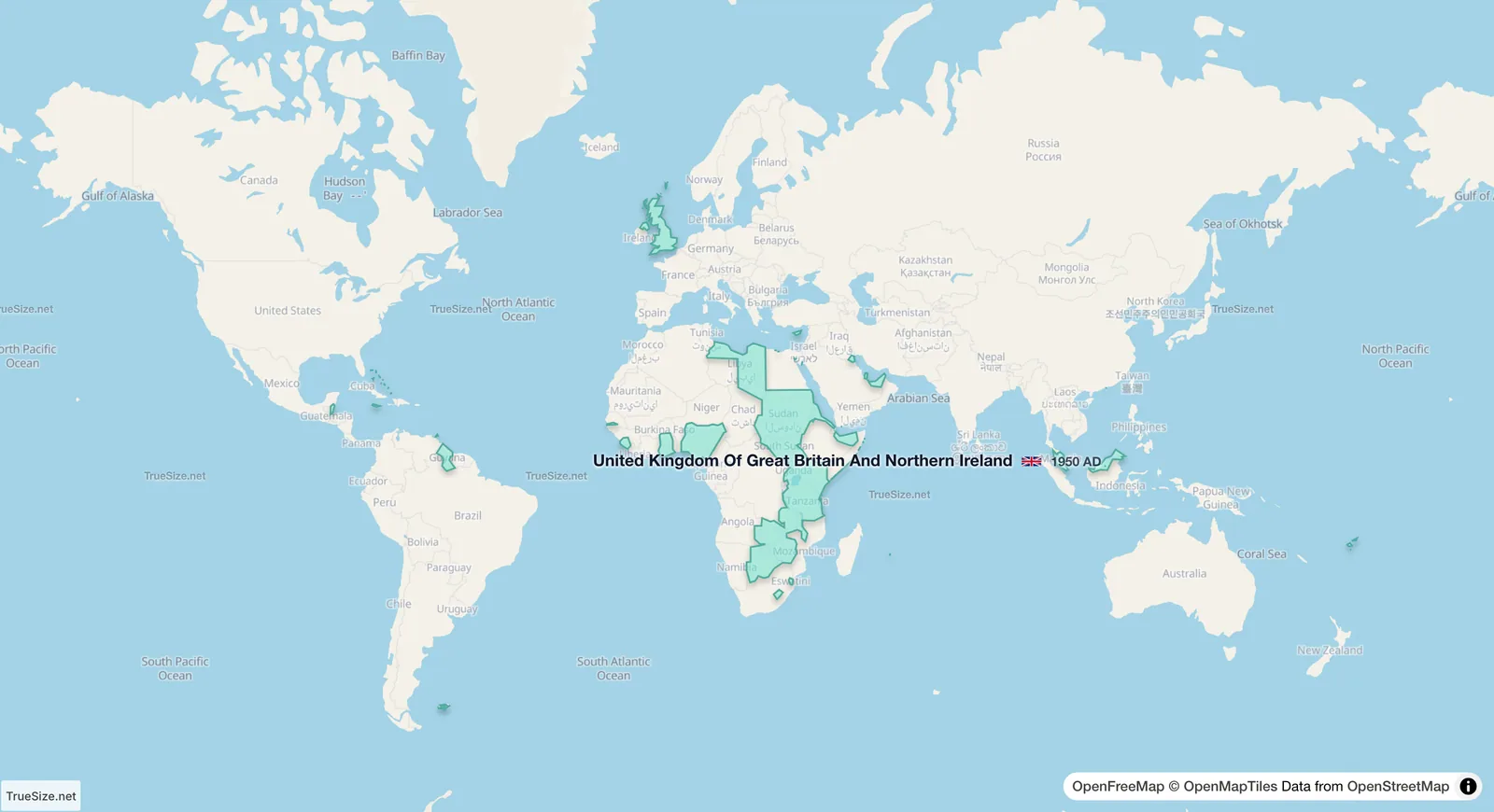
The empire in 1950: after the independence of India and Pakistan, most of what remained was in Africa.
The timeline works on the web version and in the mobile app.
Please rotate your device
The map needs portrait orientation on small screens — landscape leaves too little height to work with.