Skip to content
Ads keep this site free 🙏

Country Grid: Fill a 3×3 Grid with Countries ​

Country Grid is a 3 × 3 grid. Each row and each column says something about a country: "Larger than Germany", "English is official", "Looks 2× larger or more" on a Mercator map. Fill every square with a country that fits both its row and its column. Every country you name lands on the map at its real place, and at the end you can line up a row's countries side by side at their true size.
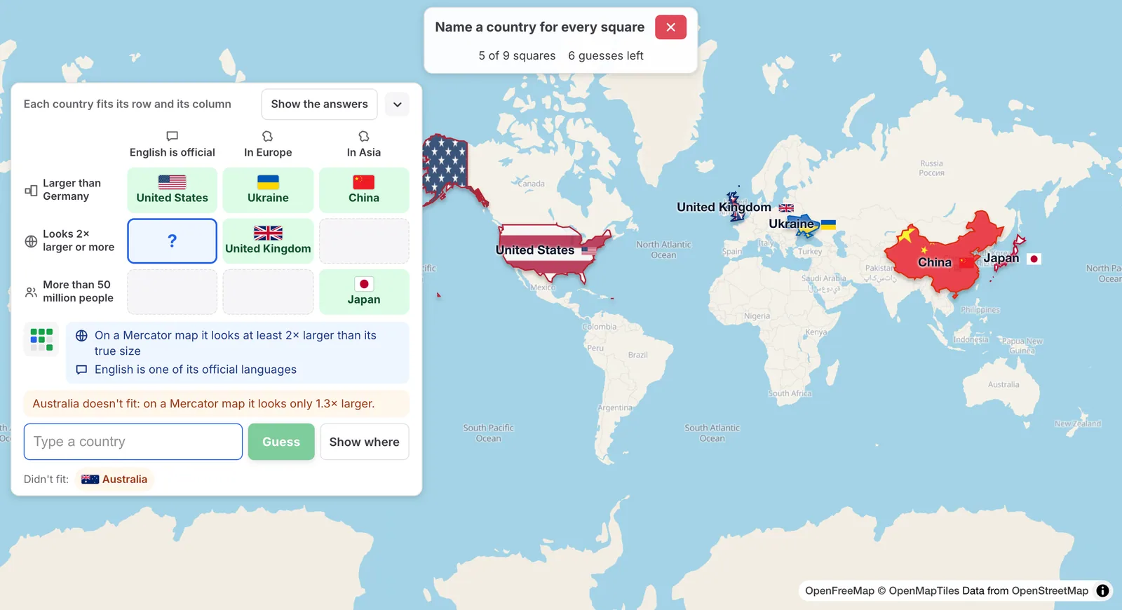
A 3 × 3 country grid at the left with five squares filled, a picked square with the line Australia doesn't fit: on a Mercator map it looks only 1.3× larger, and the five answers on the world map at home

Every country that fits lands on the map at home; a wrong one says which rule it misses.

How to play ​

  1. Open the Fun tab and click or tap Country Grid, or start at truesize.net/#countrygrid. Read the rules and click Start.
  2. Click or tap an empty square. The square's two rules show in full.
  3. Type a country and pick it from the list. You can type in your own language or in English, and common short names such as USA or UK work too. The list shows every country that matches what you typed, not only the ones that fit.
  4. A country that fits fills the square and appears on the map at home. The map does not jump: it only moves when the new country is off screen.
  5. A country that doesn't fit uses a guess, and the game says which rule it misses and why, for example "Australia doesn't fit: on a Mercator map it looks only 1.3× larger."
  6. Each country counts once in a grid. A name the game does not know, or a country already in the grid, uses no guess.
  7. Back to the grid closes the box without using a guess.

You have 12 guesses for the 9 squares, so 3 can be wrong. The grid ends when every square is filled, when your guesses run out, or when you press Show the answers.

Two squares filled, Australia doesn't fit, Canada does; then Show the answers and a row at true size

Stuck? Show where ​

Show where shades every country on the map that fits the square you picked, and moves the map to them. The square then counts half when you fill it. You can use it on as many squares as you like, so you can always finish the grid, but only a grid filled without it is worth 100.

Points ​

Each square is worth 11 points, and the whole grid is worth 100. A square filled after Show where counts half. Wrong guesses cost no points, but on the daily leaderboard players with the same points are listed by fewer wrong guesses, then by the shorter time. The time is not shown while you play; the result says how long you took.

The categories ​

  • Size: larger or smaller than a well-known country, by area.
  • People: more or fewer people than a round number.
  • Mercator map: how much larger a Mercator map draws the country than its true size, or whether it looks almost its true size. Countries far from the equator look much larger than they are.
  • Neighbours: borders a given country over land, has 5 or more land neighbours, or has none.
  • Landlocked: no coast on the open sea.
  • The equator and the tropics: the equator or a tropic crosses its land, or all of its land lies south of the equator.
  • Continent: at least a fifth of its land is in that continent.
  • Language: an official language of the country.
  • Group: a member of a group such as the European Union or NATO.

Territories such as Greenland or Puerto Rico count as answers too.

After the grid ​

Each square shows the share of players who named the same country there, and "Rare" when few did. Squares you left empty show a country that fits, in grey.
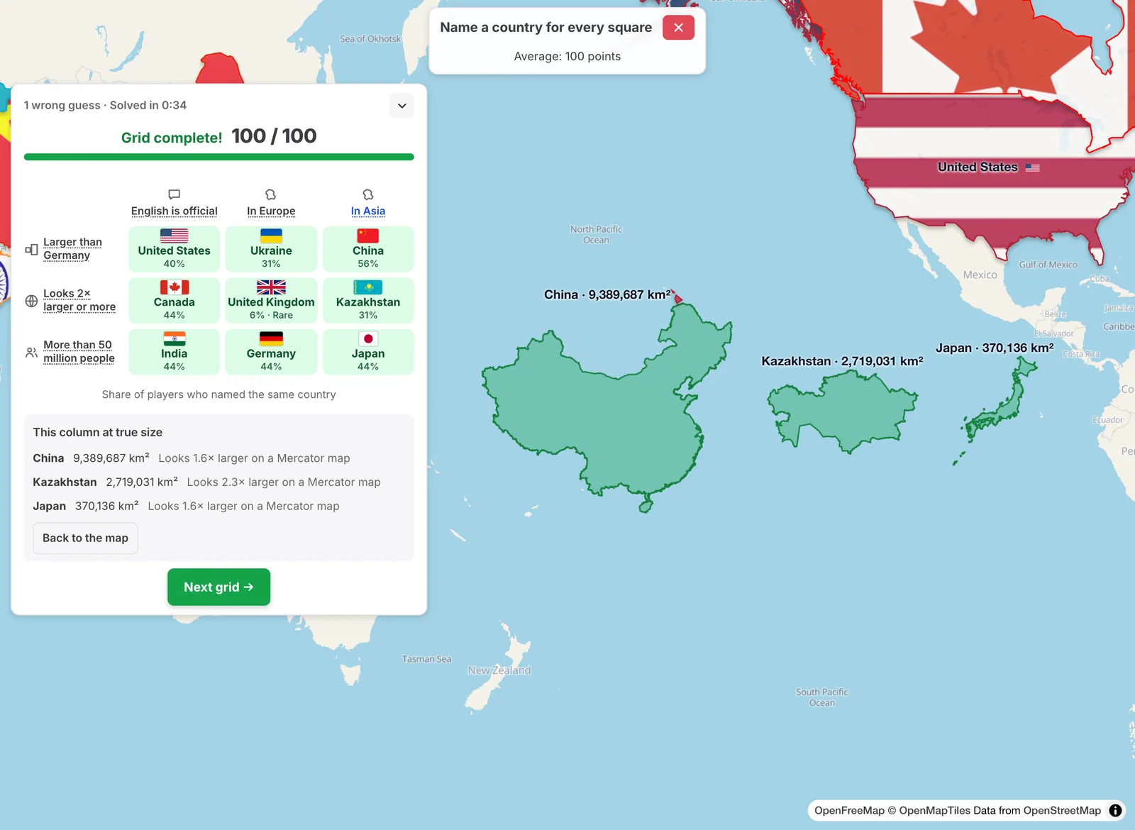
  • Click or tap a square to see the countries other players named most there, as dashed outlines on the map with their shares.
  • Click or tap a row or a column name to see its three countries side by side on the equator at their true size, with each one's area and how much larger a Mercator map makes it look. Back to the map returns to the grid's countries.
A finished grid with the share of players who named each country, and its Asia column side by side on the equator in the open Pacific at true size: China, Kazakhstan and Japan, each with its area and how much larger a Mercator map makes it look

Daily and free play ​

Country Grid is one of the daily games: one grid a day, the same for everyone. After the daily grid you see how rare your picks were compared with the other players'. In free play from the Fun tab you get a new grid every time, starting with easier grids that have many possible answers per square, then harder ones.

Tips ​

  • Start with the square you are surest of: every country you place is one fewer to choose from.
  • Large countries far from the equator look much larger on a Mercator map than near it.
  • The why line teaches you the facts: a wrong guess tells you the country's area, people or Mercator ratio.

Please rotate your device

The map needs portrait orientation on small screens — landscape leaves too little height to work with.